


— Nomos and Cosmos
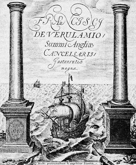
The 1620 frontispiece of Francis Bacon’s Instauratio Magna depicts a sailing vessel passing through the Straits of Gibraltar between the fabled Pillars of Hercules into the open sea. The vessel is leaving the waters of the Mediterranean for the Atlantic. The scene depicts the moment before the crossing but curiously, rather than being rendered from the point of view of those left on the European shore, the ship approaches a viewer who already stands somewhere in the Atlantic, looking back to the East and perhaps even backwards in time. The scene marks a turning point not only for the Mediterranean, whose centers of power were moving westward toward Portugal and Spain, but also for the Americas, whose fate was already irrevocably changing. Looking at this image today, one cannot help but think how this scene prefigures a paradigmatic moment that will be repeated for centuries to come. Perhaps unwittingly, Bacon’s image of the approaching ship places us in the perspective of the soon-to-be-colonized, standing on the shore at the moment of first contact.
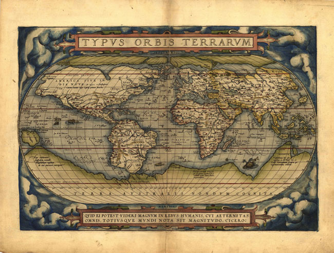
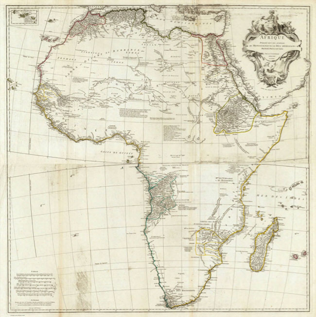
Some fifty years earlier in Antwerp, a mapmaker named Abraham Ortelius published an atlas that would prove to be the definitive geographical reference within Europe until Gerard Mercator’s fifty years later. Titled Theatrum Orbis Terrarum, or Theatre of the World, the project brought together eighty-eight different cartographic references, inaugurating the era of modern mapmaking and providing an image of the earth, its seas, and its continents that combined unimaginable accuracy with medieval ethnographic and geographic speculation. Between the early colonial period and the late nineteenth century, these fantastic geographies would be erased in the name of scientific objectivity, giving rise to that period’s dominant cartographic myth—what Joseph Conrad’s narrator Marlow called “the blank spaces of the earth.” The first of these were maps such as Jean-Baptiste Bourguignon d’Anville’s Afrique of 1749, which distinguished itself from the maps that came before by drawing a frontier between the black ink and the white page, between the known and the unknown, the occupied and the empty. 1 “It is important to note that cartographers such as d’Anville significantly reduced not only the amount of speculative topography on the map, but also ethnographic information with which earlier mapmakers had filled Africa’s interior spaces, such as the names of tribal groups. The map that attracts the young Marlow is the product of this epistemological shift: purged of hypothesis and tentative accounts of population, it leaves inviting and evident gaps in the knowledge of South America, Africa, and Australia.” Alfred Hiatt, “The Blank Spaces of the Earth,” The Yale Journal of Criticism, Vol. 15, No. 2 (2002): 223–250.
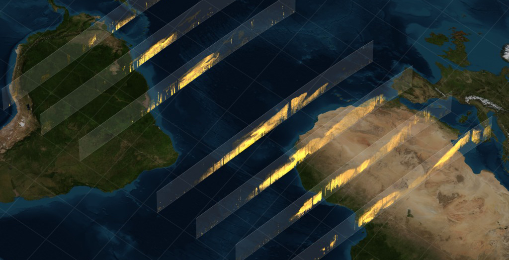
Today, the colonial frontier between the known and the unknown no longer marks the difference between black ink and white page that so enticed colonial expansion and plunder. It marks a threshold between high and low resolution. Scientists are currently exploring various proposals for dating a new geological era called the Anthropocene, whose candidates include the methane released from the first human agricultural communities around 5000 BCE, the liberation of coal-based energy during the Industrial Revolution, and the radioactive fallout from the first atomic tests in the 1950s. However, in 2015 scientists exploring atmospheric changes recorded in high-resolution Antarctic ice cores made an astonishing discovery, which might serve as the most powerful and clear indicator of widespread anthropogenic planetary transformation, the very first evidence of man-made climate change. In the space of the fifty years between the publication of the Theatrum Orbis Terrarum in 1570 and the Instauratio Magna in 1620, something entirely unexpected happened to the earth’s atmosphere: global CO2 levels suddenly plummeted.2 Simon L. Lewis and Mark A. Maslin, “Defining the Anthropocene,” Nature, No. 519 (2015).
But why such a sudden transformation in CO2 levels centuries before the invention of steam and combustion engines? The most recent estimates suggest that colonization of the Americas cost native populations fifty million lives.3 See Charles C. Mann, 1491: New Revelations of the Americas Before Columbus (New York: Vintage Books, 2006); William M. Denevan, The Native Population of the Americas in 1492 (Madison: University of Wisconsin Press, 1992). Besides written accounts of the decimation, a macabre testimony survives in the earth’s stratigraphy. The historical record hidden in the ice cores suggests that when populations in the Americas disappeared there was no one left to maintain their cities, and trees soon reclaimed large tracts of the former farmland—all the towns, the canals, the earthworks, and the causeways, essentially all the evidence of the great Amazonian and Mesoamerican civilizations, quickly reverted to forest. Within a few generations the Amazon surged and reoccupied what the conquistadors had destroyed. Thirsty for CO2, the unprecedented increase in plant life was so vast as to leave its mark in the global atmospheric record. This could only have occurred because the genocide was so complete.4 In fact, only months earlier, in January 2015, another scientific paper converged on a related conclusion, but starting with a very different premise. While examining lake sediment in Peru and Bolivia, scientists discovered deposits of metals consistent with chemicals used in the industrialization of mining. Recall that it was from here, in the depths of the Cero Rico de Potosi mine, that a river of silver ran all the way to Spain. See Chiara Uglietti et al., “Widespread pollution of the South American atmosphere predates the industrial revolution by 240 y.,” Proceedings National Academy of Science PNAS, No. 112 (2015).
At the 2009 United Nations Climate Change summit, Lumumba Di-Aping, the lead negotiator for the G77, which represents 132 developing nations, uttered the word “genocide” again, but now with the word “climate” before it. Di-Aping aimed the two words squarely at the G20, accusing them of an attempt to “colonize the sky.” The claim arrived in the midst of negotiations haunted by the specter of financial meltdown the year before. Crowds of activists waited outside the Bella Center in Copenhagen, wondering if an accord would be signed in the wake of Kyoto. Inside the convention center, as negotiations were falling apart, Di-Aping called an impromptu press conference for delegates from civil society organizations. The unscheduled event began with a request by Di-Aping that all recording devices be turned off. In the minutes that followed, a profound rupture in diplomatic protocol was to unfold as a private calculus became public. For days before and unbeknownst to the G77, a secret draft agreement was being circulated exclusively among G20 members. As in the Berlin Conference 125 years before, African nations were once again being excluded from deliberating on their own fate—only this time the scramble for colonial surfaces had been replaced by a scramble for colonial heights and depths. This fact alone justified Di-Aping’s invocation of colonialism, but it was far from the most worrying aspect of his presentation.
On the fourth line of the second paragraph, the draft agreement proposed a commitment to a maximum two-degree global temperature increase above preindustrial levels. Within this number, a calculus of life and death was erased. The violent abstraction of a global average negates the uneven scale of climate impact and erases the specificity of people from its calculation. A two-degree average increase globally would allow for a catastrophic 3.5-degrees in many of the countries Di-Aping represented.
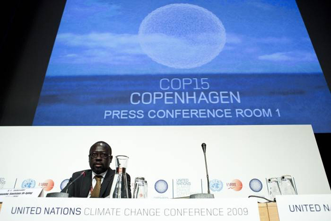
The most recent report on climate impact in Africa by the World Health Organization suggests that Di-Aping’s use of the term “genocide” was far from rhetorical. Mortality rates due to malnutrition and disease between 2030 and 2050 are expected to be on the order of 250,000 per year, excluding factors of heat stress exacerbating social and civil conflict.5 Simon Hales et al., Quantitative Risk Assessment of the effects of climate change on selected causes of death, 2030s and 2050s, World Health Organization (2014). Yet, members of the press were indignant, incensed that a Sudanese diplomat would return the accusation of genocide from the South to the North.6 Only fifteen months earlier, in July 2008, the Chief Prosecutor of the International Criminal Court, Luis Moreno Ocampo, had made a similar claim, albeit in a more familiar direction, when he issued an arrest warrant for the Sudanese President Omar al-Bashir for his role in the violence in Darfur. Some sections of the media tried to deny Di-Aping’s legitimacy as a spokesperson by virtue of his Sudanese heritage—and yet, is it not possible that it was precisely his intimate knowledge of events in a part of the world so affected by colonialism and its environmental legacies that lent his claim not only legitimacy but a visceral charge of reality?
The complexity of the earth’s climate makes it difficult to trace a line between cause and effect. The planet is like a reservoir of complication you can dip into to hide your tracks. Because CO2 is relatively long-lived in the atmosphere, it tends to disperse more easily than other pollutants; moreover, because all its molecules are identical, carbon dioxide has no fingerprint. Aerosols, however, are a different matter.7 See J. M. Prospero et al., “The Atmospheric Aerosol System: An Overview,” Review of Geophysics and Space Physics, Vol. 21, Issue 7 (1983); S. K. Satheesh and K. Kirshna Moorthy, “Radiative effects of natural aerosols: A Review,” Atmospheric Environment, Vol. 39 (2005). In 2006, a research team led by Alessandra Giannini at Columbia University’s Earth Institute made a very beautiful discovery whose full implications are yet to be felt.8 Michela Biasutti and Alessandra Giannini, “Robust Sahel drying in response to late 20th century forcings,” Geophysical Research Letters, Vol. 33 (2006). For an overview see Alessandra Giannini et al., “A global perspective on African climate,” Climatic Change, Vol. 90 (2008); Alessandra Giannini et al., “A unifying view of climate change in the Sahel linking intra-seasonal, interannual and longer time scales,” Environmental Research Letters, Vol. 8 (2013). They were studying the temperature of the surface layer of the Atlantic Ocean, especially the Intertropical Convergence Zone: the part of the ocean where warm water heated in the tropics mixes with cooler water coming from the poles. Because of the earth’s spherical shape, the equatorial oceans and atmosphere receive more solar energy. Like rail lines and freeways, ocean currents and prevailing winds are bits of infrastructure, except that they are not fixed in place by concrete and steel and they exist in order to move energy around. Giannini and her team discovered that the monsoons that bring seasonal rain to the African continent are highly sensitive to changes in the temperature gradient between hot and cold water, their interaction becoming more or less turbulent depending on the temperature differential. This turbulence drives moisture supply to the atmosphere and increases the intensity of African monsoons.
This discovery has profound implications beyond climate science. Scientists have known for some time that human activity is influencing surface temperatures in the Atlantic Ocean. This in itself is not remarkable; there is barely anything on earth that humans have yet to touch. But it is not human activity as such that is affecting change; rather, industrial activity in the Northern Hemisphere, specifically the emission of aerosols from the combustion of fossil fuels, is forcing temperatures to increase.9 Leon D. Rotstayn and Ulrike Lohmann, “Tropical Rainfall Trends and the Indirect Aerosol Effect,” Journal of Climate, Vol. 15 (2002).Unlike CO2, every aerosol particle is unique and short-lived, making the particles fiendishly difficult to calculate within climate models, but very useful for climate forensics. For some time climate science has also known about the measurable decrease in temperature that can occur due to aerosol emissions, known as “dimming.” This is why areas downwind of industrial centers can experience temperatures lower than expected, and also why Turner painted such beautiful sunsets in 1816—the year without a summer, when Mount Tambora’s volcanic activity poured huge amounts of particulate matter into the atmosphere.10 C. S. Zerefos et al., “Atmospheric effects of volcanic eruptions as seen by famous artists and depicted in their paintings,” Atmospheric Chemistry and Physics, Vol. 7 (2007).
For years, it was believed that drought and famine in the Sahel region of northern Africa were being exacerbated by poor farming practices leading to land degradation. The dominance of this logic led to a disastrous epistemic conflict, as proposals for reforming agricultural practices by foreign nongovernmental organizations supported by masses of quantitative analysis came into contact with indigenous forms of knowledge that had always understood rain, soil, and crops as a set of interacting qualities. Today, anthropogenic climate change has forced a reexamination of the causes of drought in the Sahel. The once-dominant paternalism of agricultural reform is now turning on its head as science starts to understand what it means to be caught downwind and downstream of the industrial Tamboras to the north.
Di-Aping’s claim of genocide can be understood as a call for a different scale of calculus that would be a prerequisite for establishing proper terms in climate negotiations, one with just enough resolution to catch the uneven effects of temperature increase. As climate modeling improves, what once appeared to be an opaque reservoir of complication begins to reveal a hidden architecture of diffuse and attenuated relations. This architecture is a new kind of map that explains how activity in one part of the planet can affect life in another. Simulations are poised to become a medium for law and politics. Hidden in the resolution of models are crimes waiting to be prosecuted.11 See Adrian Lahoud, “Floating Bodies,” in Forensis: The Architecture of Public Truth, ed. Eyal Weizman and Anselm Franke (Berlin: Sternberg Press, 2014).
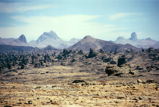
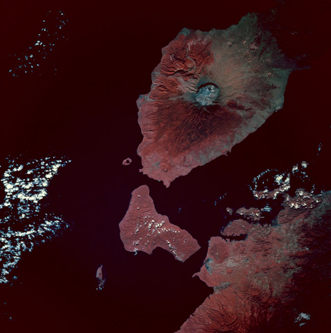
In 2006, scientists investigating the behavior of atmospheric dust came across an astonishing example of action at a distance that had nothing to do with human activity. The Bodélé Depression is an old lake bed in Chad that hasn’t held water since the Holocene. It was once rich with algae and other microbial marine life whose dried-out remains fill the lake bed. To the northwest lie the Tibesti and Ennedi mountain ranges. When the lake, the mountains, and a wind named Harmattan conspire, a powerful jet stream of air is directed at the dried algae, grinding it into powder and blowing 700,000 tons into the atmosphere in the space of only eight hours. During winter, this regular event has caused severe dust storms in parts of the African continent, but as satellite LIDAR sensors have since confirmed, this is only the beginning of a far longer journey. The scientists discovered that this dust was being carried all the way across the Atlantic Ocean, finally coming to rest in the Amazon rainforest.12 Richard Washington and Martin C. Todd, “Atmospheric controls on mineral dust emission from the Bodélé Depression, Chad: The role of the low level jet,” Geophysical Research Letters, Vol. 32, No. 17 (2005). See also I. Tegen et al., “Modelling soil dust aerosol in the Bodélé depression during the BoDEx campaign,” Atmospheric Chemistry and Physics Discussions, No. 6 (2006); Y. Ben Ami et al., “Transport of North African Dust from the Bodélé Depression to the Amazon Basin: A Case Study,” Atmospheric Chemistry and Physics Discussions, No. 10 (2011); C. S. Bristow et al., “Fertilizing the Amazon and equatorial Atlantic with West African dust,” Geophysical Research Letters, Vol. 37, No. 14 (2010). More surprisingly still, they found that the dust plays a critical role in the Amazonian ecosystem. Since heavy tropical rains leach nutrients from the soil, this airborne parcel of dead marine life was helping return the Amazonian ecosystem to nutrient surplus. The scarcity of the desert sustains the abundance of tropical forests—Saharan dust planted in an Amazonian garden. And estimates suggest that this long-range atmospheric infrastructure can continue to supply the Amazon with nutrients for another one thousand years. When there is no more dust left to transport, this pitiless supply chain will just stop.
These primordial inequalities are too indifferent and too fragmented to be unified into the discourse of planets, globes, and spheres, let alone humanity, since each of these presupposes a common perception, a common interest, and a common stake.13 See Adrian Lahoud, “The Bodélé Declaration,” in Textures of the Anthropocene: Grain Vapor Ray, ed. Katrin Klingan et al. (Berlin: Revolver Publishing, 2014; Cambridge and London: The MIT Press, 2015). But as the examples above indicate, what is common is defined by a shared commensurability; outside of this space are differences that are not made commensurable so easily. The threshold between the commensurate and incommensurate is a site of struggle, a frontier that is increasingly shaped by technoscience and its capacity to count and calculate. The frontier of calculation can be extremely violent, eradicating preexisting values and distinctions—this tension was always at the heart of decolonization struggles. But it is also a vital part of building communities of shared inquiry, especially scientific ones.
The forensic scientist Edmond Locard suggested that every contact leaves a trace. It was a theory of cause and effect based on material residue. The crime scene was a territory whose limits and history were marked by the traces of these contacts. In the case of climate change and environmental violence, however, the contact drifts apart from its trace; it gets carried away on ocean currents and lost in the atmosphere. But simply reconnecting causes to effects from evidence waiting to be found in ice cores, or through ocean temperatures waiting to be predicted by climate models, will mean little to claimants for environmental justice until institutions that are sensitized to the resonances in this evidence are built. Existing institutions for climate negotiation like the UNFCC don’t really negotiate temperature; they fight over GDP and greater access to a share of carbon capacity. Thus, was Lumumba Di-Aping justified in suggesting that today the sky itself is being colonized? In what sense can an atmosphere be colonized in the first place? It is clear that land can be expropriated. But how do you calculate and then privatize, subdivide, trade, and develop an atmosphere? And not only atmospheres—what about social ties, or credit ratings, or even self-worth? If this proves too difficult to imagine, just recall the vessel approaching us in Bacon’s frontispiece and ask yourself whether it was any more difficult to imagine the expropriation of land for those who stood on the shore waiting for the boat to arrive.
×

